Microsoft has a busy day one at Ignite 2016 yesterday. Amongst the barrage of announcements was ArcGIS Map for Power BI, created by Esri. More specifically, this is a preview and Microsoft took to its Power Bi blog to detail some of the features.
The company says that maps are important for understanding data and empowering decisions. Power Bi is moving beyond traditional maps and is creating new capabilities. Microsoft collaborated with Esri, a major name in the geographic information systems (GIS) sector.
If you are unfamiliar on GIS, it combines data layers with special analysis on a map. This allows a better understanding of locations. Microsoft says that Power Bi customers can now use the ArcGIS Maps from Esri in preview.
In a new blog post, the company details some of the features and functionality of the service.
“Once you're using the Esri visual, you'll receive access to features that take mapping beyond the presentation of points on a map into the land of GIS.”
Features
Using the Esri visual, users can access full screen editing. A small pencil located at the top right of the screen provides access to the edit mode. There are four base maps supported, including open street maps. Esri's standard ArcGIS map is also available.
Power Bi users can also choose between various themes. Themes change how the data is presented on a map. Some of the themes include point and shape based maps. Heat maps are also useable in most scenarios to highlight maps clusters.
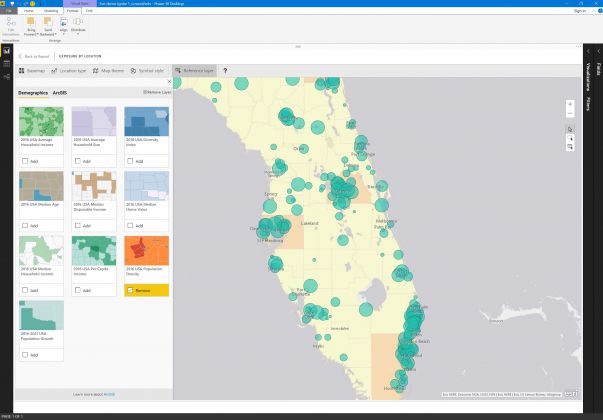
One feature Microsoft is particular proud of allows users to add reference layers. Esri provides demographic layers allowing for deeper analysis with reference information. The company says this allows more context from the data in Power Bi. More than this, users can select layers that they have chosen, allowing for multiple references.


