Online mapping tools are vital for travel planning, but many also provide supplementary tools. Google Maps can measure distance in an area or as the crow flies to help you with various decisions and sate your curiosity.
Measuring distances on Google Maps is a powerful tool that goes beyond just finding directions from one place to another. This feature allows users to determine the exact distance between two or more points anywhere in the world. It’s particularly useful for activities like planning hikes, measuring property boundaries, or even for curiosity’s sake.
The distance measuring tool is accessible both on desktop and mobile versions of Google Maps. On desktops, this feature can be used directly from the web browser, while on mobile devices, it’s available within the Google Maps app for both Android and iOS. The process varies slightly between platforms, but the core functionality remains the same.
How to Measure Distance With Google Maps on the Web
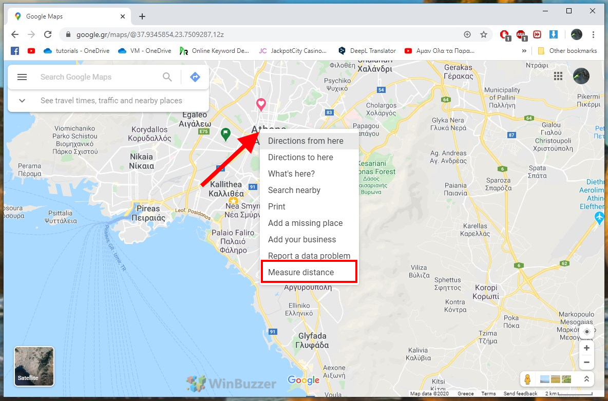
Go to maps.google.com. In the map view, right-click on the desired starting point and select “Measure Distance”.
To measure the distance to another location on the map as the crow flies, simply click on it with the mouse. Google Maps will show you the exact distance in kilometers and meters as well as miles in an info box.
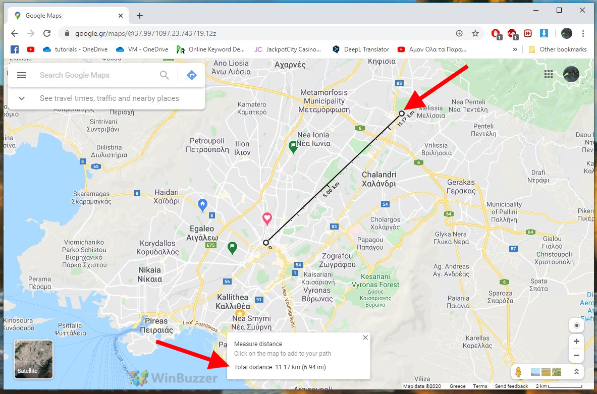
You can also extend the measuring path with additional points to follow the course of a road. This can be used to measure the distance of a route.

How to Measure an Area With Google Maps on the Web
To calculate a surface, simply use the ruler function to set the points along the outer boundaries of the desired surface until the end-point corresponds to the starting point.

With the satellite view, this works especially well for properties. The total area appears like the measured distance in the info box.
How to Measure Distance with Google Maps for Android
You can also measure a distance as the crow flies with the Google Maps app for Android and iOS. Tap the starting point on the map to select it with a red marker, then tap on the name of the location below to open the details.

You’ll then see an option to measure distance. Tap it.

You can move the map and select your destination, at which point the distance will be displayed below.
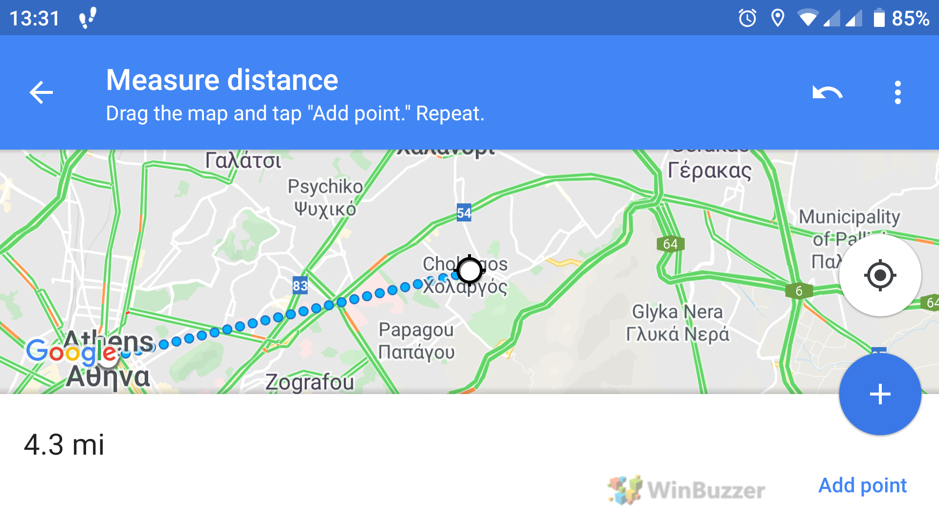
You can use the blue plus button to add more points on the route for use in more complex calculations.
FAQ – Frequently Asked Questions about Measuring with Google Maps
Can Excel calculate the distance between two addresses using Google Maps data?
No, Excel itself doesn’t integrate directly with Google Maps for distance calculations. However, you can use third-party add-ins or tools that link Excel with Google Maps APIs for such purposes.
How do you save measured distances or areas in Google Maps for future reference?
Google Maps does not have a direct feature to save measured distances or areas. You would need to take a screenshot or note the measurements manually for future reference.
Can you measure elevation changes along a route in Google Maps?
Google Maps does not directly show elevation changes along a measured route. For elevation details, you might need to use specialized apps or tools like Google Earth.
Is there a limit to the number of points I can add when measuring distance in Google Maps?
There is no official limit stated by Google, but the map may become difficult to navigate with too many points, and performance may decrease.
How do I measure the perimeter of an area in Google Maps?
To measure the perimeter, use the same method as measuring an area. The total perimeter will be shown along with the area measurement.
Can Google Maps measure the distance of a non-linear path, like a river or hiking trail?
Yes, by adding multiple points along the path of the river or trail, you can measure its distance in Google Maps.
How do I change the distance units in Google Maps from miles to kilometers or vice versa?
Change the units in Google Maps settings. On mobile, tap your profile picture > Settings > Distance units. On the web, click the menu > Settings > Distance units.
Can I use Google Maps to measure distances underwater, like across a lake?
Yes, you can measure distances over any terrain, including water bodies, by plotting points across the lake.
How do I find the latitude and longitude of a point in Google Maps when measuring distance?
Right-click (web) or tap and hold (mobile) on the point and select the “What’s here?” option to see its latitude and longitude.
Can I use Google Maps to measure distance on other celestial bodies like the Moon or Mars?
Google Maps is limited to Earth. For other celestial bodies, consider using specialized applications like Google Earth’s space feature.
How can I print the map with the measured distance or area?
After measuring, take a screenshot of the map and print it. Google Maps does not offer a direct print feature for measurements.
Is the Google Maps distance measurement tool available in all countries?
Yes, the distance measurement feature is available worldwide, wherever Google Maps is accessible.
Can I share the measured distance or area with others directly from Google Maps?
While Google Maps doesn’t offer direct sharing of measurements, you can share a screenshot or manually note the measurements to share.
How do I access historical data for a location when measuring distances in Google Maps?
Google Maps does not provide historical measurement data. For historical imagery or data, use Google Earth.
Can I integrate Google Maps distance measurements into a custom app or website?
Yes, by using Google Maps APIs, you can integrate distance measurement functionalities into custom apps or websites.
Extra: How to Create a Custom Google Map
Google Maps is among the best tools for route finding, but sadly many of its more advanced features are tucked away. Though it’s not widely advertised, it is possible to create a custom Google map with its own pins, styles, routes, and more.